一直跟踪马航370的中英文报道,刚看到下面的评论, 尽管不完全同意作者的看法。 但觉着可以让大家看看。请不要拍砖头啊。另外,根据公布的最后国际海事卫星失连的可能的南北两区和其他数据, 我们的计算是: 飞机的最后去处应在马来西亚时区以西的世界时区的(UTC+6)时区内, 也就是说在法属Amsterdam岛时区(UTC+5)的东面(如果不在相应的北区走廊的话)。我们知道这个计算结果的重要意义。 这也是我们第一次在实际事例应用我们的理论算法, 希望能提供一点力所能及的帮助。
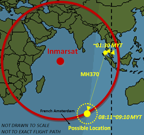
鉴于目前各种有关MH370下落的猜测,我们有理由相信,这架飞机可能位于以下区域之一。 这是根据由马来西亚政府公布的南北走廊的信息和我们选择的其它数据计算得来的。
1、南印度洋的南部走廊如图中橙色圆圈。
2、在北部走廊相对应的区域。
由于北部走廊地区是涵盖陆地和高度军事化(例如,驻扎有雷达),可替代的唯一的高度可能性是在下面的地图中在南印度洋中围绕或在橙色区域内为中心点。请注意,地图绘制未按比例,并且也不代表飞机的精确飞行路线。我们使用的是我们自己的一种特有算法和理论框架结构进行的计算。我们的计算是基于我们认为是相关和可信的来源和公开发布的信息。我们并遵守在开展科学研究的基本原则。
我们的图纸是不按比例,并不代表MH370实际所作出确切的飞行路径,因为我们没有国际海事卫星组织定期从MH370的间隔“握手”的形式中获得的数据,我们也无法对飞机加注燃油的数据量来估算空中飞行的持续时间。我们可以简单地假设用在飞机和国际海事卫星之间的40度角(公布的最终“握手”接触的信息8:11[MYT])是一个常数,并与其他选定的数据合并使用。精确确定 MH370位置需要进一步的数据和大量的额外计算,这取决于飞机在8点11分(MYT)最后的“握手”时的实际的高度,并且在那时刻向在地球表面投射的锥型区域; 这个区域取决于MH370在最后的“握手”瞬间的飞行高度(即,如果MH370的来自地球表面的位置= 0,则投射的阴影面积= 0); 并要考虑777 ER- 200在其双发动机停止工作后可滑翔长达20分钟的距离。我们的命题预测大体步骤列举如下。
1、我们有充分计算理由相信,飞机与国际海事卫星的最后一个“握手”是在日出前发生的。
2、2014年3月8日吉隆坡日出的当地时间( MYT )是7时21分。
3、这架飞机最后一次同国际海事卫星组织在印度洋上空的卫星“握手”是在08:11 ( MYT ),以下我们推断飞机与国际海事卫星最后一次接触(ping)发生在一个从8点11分至9点10 ( MYT)的范围;我们来假定,国际海事卫星组织的“握手“间隔是一个小时计算(实际为半小时)。
4、因为吉隆坡MYT时区日出为UTC +8:00,最后一个“握手”的MH370的位置应该已95%的很高概率在UTC +6:00时区内,如果扩大的话:在UTC+5:00或UTC +7:00时区的30分钟内。 这受飞机在于上午08时11分( MYT )最后一个“握手”的高度制约。
5、请使用上述建议时区同已公布的南部和北部走廊相重叠覆盖, 你会通过绘制得到一个近似菱形的区域。这会显著缩小搜索区域; MH370的777飞机一般或许会在保持其结构完整性情况下在大洋的水下,取决于其机身承受水压的能力。
6、因为我们本来已经知道如果飞机是在北部走廊的某处(大多数国家在北部走廊已公开宣布,他们的雷达系统在该窗口的时间没有检测MH370或任何其他UFO),这给我们留下唯一推断, 777 ER 200 (又名MH370 )应该是在印度洋南部的澳大利亚西部和法国阿姆斯特丹岛东北之间的某处,这是我们唯一选择。
7、上面推论已经显著减少了可能的搜索区域,并提供了大致地图该从那个中心-范围进行搜索。
(2014年3月19日上午09时09分25秒, Alan Pan and David Pan)
Where Could Be A Possible Location for MH370?
In light of current speculations in a wide range for whereabouts of MH370, we have reason to believe that the plane may be located in one of the following areas according to the corridors announced by Malaysian government and other data we have selected for calculation.
- The middle of the southern Indian Ocean as encircled in orange in the south corridor, or
- The corresponding area in the north corridor.
As the area of north corridor is most covered by land masses and heavily militarized(i.e., stationed with radars), the only high possibility of the alternative is around or within the orange area in the southern Indian Ocean as circled in the map below. Please note that the map is drawn not to scale and not to the exact flight path. We have made our calculations using our proprietary algorithm and framework. Our calculation is based upon the published information we have selected from the sources we deem to be relevant and credible. The fundamental principles in conducting a scientific research have been followed.
Our drawing is not to scale, neither to represent the exact flight path actually made by MH370 because we do not have the Inmarsat data that was periodically received in form of the interval “handshakes” from MH370, nor we have the data on the air fuel amount that could be used to estimate the air flight duration. We simply can assume the published information of the final contact at a 40 degree angle between the plane and Inmarsat to be a constant and used it with other selected data. Any further pinpoint of MH370 location will require additional data and extensive calculations, depending upon the actual altitude the plane was flying at the last “handshake” at 8:11(MYT)and the projected shadowed area that is drawn on the surface of the earth, depending upon the flight height of MH370 at the moment of the last “handshake”(i.e., if MH370’s position from the earth surface = 0, then the projected shadowed area = 0). Our projected propositions in steps are listed as follows.
- There is substantially strong reason to believe that the plane’s last “handshake” with Inmarsat happened before sunrise.
- The sunrise was around 07:21 local time(MYT)in Kuala Lumpur on March 8, 2014.
- The plane was last pinged by the Inmarsat’s satellite over the Indian Ocean at 08:11(MYT), hereafter inferring the plane’s last contact with Immarsat has occurred in a range from 08:11 to 09:10(MYT)if the Inmarsat’s “handshake” interval is at a hourly rate.
- Because the time zone for the sunrise at MYT is UTC+8:00, MH370’s location of the last “handshake” should be marked within UTC+6:00 time zone with a high probability, if not within UTC+5:00 or UTC+7:00 time zone.
- Please use the above proposed time zones to overlay with the published southern and northern corridors. One will narrow the search areas significantly by drawing the scope of the areas of where the MH370 ‘s 777 can be located.
- Since we would have known already if the plane were somewhere in the land area in the north corridor(most nations in the north corridor have publicly announced that their radar systems did not detect MH370 or any other UFO during that window time), this leaves us with the only alternative to infer that the 777 ER 200(a.k.a. MH370)should be somewhere between the west of Australia and the northeast of French Amsterdam Island in the southern Indian Ocean.
- The above has significantly reduced the possible search area and offered the center from which the search should be conducted.(3/19/2014 9:09:25 AM, Alan Pan and David Pan)
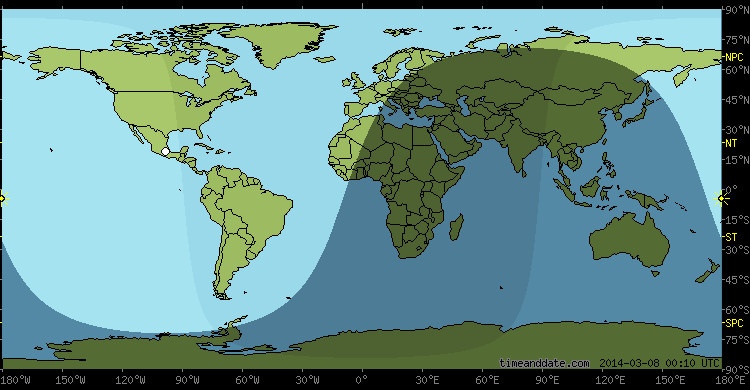
Conceptual Rendition of MH 370 Possible Location
Based upon the selected published information using our proprietary algorithm and theoretical framework
(either area of UTC+6:00 time zone intercepting with the published southern and northern corridors as shown)


Adopted from:
http://www.timeanddate.com/astronomy/moon/light.html?n=122&day=8&month=3&year=2014&hour=8&min=10&sec=0
http://www.inmarsat.com/news/inmarsat-statement-malaysia-airlines-flight-mh370/
转发:马航引爆全球新闻战 中国媒体败北暴硬伤
事关154名中国人的身家性命,马航事件真相截至目前几经反复才终于在西方媒体的逼问下才逐步还原。在此中,中国媒体却再度暴露出自己在专业媒体素养以及职业操守上的软肋,引发舆论界的不满与反思,甚至被讽刺“中国媒体有三宝:转发、蜡烛和祈祷”。包括亚洲新闻社社长将徐静波等职业媒体人和民间舆论纷纷撰文炮轰中国媒体的表现。诚然,中国媒体的败落似可大部分归咎于中共舆论体制以及国家实力,但这并不足以成为为其开脱的理由。
3月17日17时30分在马来西亚召开的例行新闻发布会上马来西亚交通部长希山慕丁承认“仍有相关信息未透露”,这一发言证实了此前西方媒体一系列推测。事实上,早在3月15日马来西亚总理纳吉布紧急回应西方媒体揭示失联马航航班远不只是简单的飞机失事的时候,中国媒体“沉溺”于对善后事宜的关注以及对遇难者家属看似悲情实则冷漠的报道便逐渐显露其令人失望的迹象。而且在这场中国媒体与世界媒体赛跑的轮番“爆料”中,独独缺少马航失联客机154名中国人所在国的中国媒体“独家信息”的身影。
此次马航失联客机事件的扑朔迷离,着实让全球各路媒体经历了一场无硝烟的新闻战。而因为失联客机乘客中154名中国人的存在,中国媒体的表现也倍受瞩目。我们看到的是,中国媒体的确站在安排失联乘客家属的丽都酒店的第一线,他们也站在了北京首都机场马航新闻发布会的第一线,但他们的报道大多要么局限在新闻发布会说了什么、家属什么表情、发言人和负责人的表现云云,要么陶醉在肤浅的煽情主义,在报端网格中“抒发一下情怀”。而真正的,诸如“客机失联是劫机还是事故?”“失联客机是降落还是空中解体?”“客机失联事件是谁策划?乘客或机组人员或其他?”……这些新闻出现在中国媒体的报道却变成了“据CNN报道”“路透社的最新消息说”“《纽约时报》透露”……也就是说,除了站在新闻发布会、除了在机场拍摄机长悲愤家属的照片外,中国媒体“毫无有价值的作为”。
亚洲通讯社社长徐静波在其《中国媒体在马航客机新闻战中为何失败》的文章中分析了中国媒体失败的原因。原因一:中国媒体没有强大的数据情报网。英美新闻媒体的爆料大多来自军方、卫星公司、情报机构。不过,中国媒体显然不能如此无孔不入。徐静破说,中国政治下形成的中国媒体,他们一直是在被动中成长并已经习惯这种模式,“他们已经丧失了主动出击的能力。也就是说,“听传达”变成了职业,而‘挖消息’变成了大忌。这就注定,中国央媒是养尊处优的公主,而不是四处寻生的小贩。”
3月16日中国中央电视在电话连线中透露,MH370上有一名非常值得怀疑的乘客:中国出生,土耳其受教育,在英国教了两年书,去瑞士学了飞机发动机知识。但此“可疑人物”的出现是在事发后的第天后,未免过于“姗姗来迟”。在此之前,西方媒体早已经将目光转向劫机以及更为可疑机长、副驾驶。舆论质问这无疑更突显了央视跟在人身后的、被人牵着鼻子走的被动姿态。
一位媒体人在朋友间聊天时称,自马航事件发生后,他的路线就是丽都酒店、北京首都机场、发布会,而这路线还不包括报社。如若碰到诸如3月15日新闻发布会取消的情况,这位摄影记者朋友只能悻悻然与其他媒体同行跑到咖啡馆“蹭蹭免费WiFi”,然后询问着彼此“你们那儿有爆料么?”彼此间默然以对,然后加上,“最新消息”说了什么,而这些“最新消息”往往是来自英美媒体,如CNN、BBC、路透社、《纽约时报》……然后彼此再尴尬的笑笑,“当然,大家都知道了”,再然后,转移话题。
徐静波列举的第二个原因是:中国媒体没有专家型记者,吃“年轻饭”。徐静波举例称,《纽约时报》在3月8日马航失联事件发生1天后调集了30名资深记者成了报道团队,在第一时间写出了18篇报道与分析文章。徐静波不无无奈的呃表示,此后的事件演变,证明了纽约时报和华尔街日报、CNN、BBC、金融时报等英美新闻大鳄的实力——从卫星数据到通讯记录,从飞行轨迹到飞行时间,一件件搞到手,一件件抖露出来,虽然马来西亚一次次否认,最终还是纸包不住火,在15日的总理记者会上,承认了媒体报道的众多事实。
反观中国媒体,3月13日《法制晚报》发布《直击:5大疑点指向马航曾折返马六甲》,文章中的措辞是“马来西亚官方已经公布14份声明,但法晚记者梳理发现”“有最新消息显示”“据《华尔街日报》报道”……3月17日《中国青年报》在其《四大疑点指向失联航班机长》文章中的措辞是“美国有线电视新闻网(CNN)15日称美国情报部门”“英国有影响的大报《镜报》、《每日邮报》16日均报道”“据英国《每日电讯报》16日报道称”“与此同时,菲律宾媒体16日也援引菲民航署消息称”“据马来西亚当地媒体《马来邮报》3月14日报道说”……从中发现,其中的“解析”“疑点”其实仅仅是之前媒体报道的“在解读”而已,并无“独家”,并无“新意”,更不需要马航方面、马来西亚官方“承认”和“证实”什么。俨然,中国媒体变成了“跟屁虫”。
其实中国媒体这种“败北”这种现象并非马航失联事件引发的新闻战独有,在中国官方尚未明确周永康案时,3月2日政协会议首次记者会上,香港记者提出了周永康的“敏感问题”,中国大陆媒体显出“弱势”;在3月13日中国国务院总理李克强记者会上一片“和谐”,对于媒体关注的周案闭口不提,中国媒体噤声,外媒却在事先被会务组新闻官“打招呼”,明确要求勿提“你懂的”(即周永康)问题,越线将列黑名单,外国记者以后不给工作签证。《纽约时报》记者在推特发文,抱怨两会开始还有新闻发言人说“你懂的”,但结束“啥都没懂”。另有美国记者感叹,“没有昆明,没有周永康,没有西藏,中国总理记者会,新闻死了。”
敢于实名举报原国家发改委副主任刘铁男的原《财经》杂志副主编罗昌平评论称,围观马航失联事件,CCN、美联社、路透社、纽约时报等,基本垄断了关键信息的发布权,并对马来西亚形成倒逼反证,从而拼凑相对完整的信息流。从这种意义讲,中国没有一家真正的国际媒体,自然提供不了核心信源。信息时代,所谓大国,以及软实力,拥有一个国际媒体组合也应该是大国的标配,利大于弊。也许可以说,“你懂的”,其信息量涵盖量大到让人“无法真正懂的”
Where Could Be A Possible Location for MH370?
In light of current speculations in a wide range for whereabouts of MH370, we have reason to believe that the plane may be located in one of the following areas according to the corridors announced by Malaysian government and other data we have selected for calculation.
The middle of the southern Indian Ocean as encircled in orange in the south corridor, or the corresponding area in the north corridor.
As the area of north corridor is most covered by land masses and heavily militarized(i.e., stationed with radars), the only high possibility of the alternative is around or within the orange area in the southern Indian Ocean as circled in the map below. Please note that the map is drawn not to scale and not to the exact flight path. We have made our calculations using our proprietary algorithm and framework. Our calculation is based upon the published information we have selected from the sources we deem to be credible and reputable. The fundamental principles in conducting a scientific research have been followed.
Our drawing is not to scale, neither to represent the exact flight path actually made by MH370 because we do not have the Inmarsat data that was periodically received from the interval "handshakes" with MH370, nor we have the data on the air fuel amount that could be used to estimate the air flight time. We simply can assume the final contact at a 40 degree angle between the plane and Inmarsat to be a constant and used it with other selected data. Any further pinpoint of MH370 location will require additional data and extensive calculations, depending upon the actual altitude the plan was flying at the last "handshake" at 8:11(MYT)and the propositions are listed as follows.
First, there is reason to believe that the plane’s last "handshake" with Inmarsat happened just before sunrise.
Second, the sunrise was around 07:21 local time(MYT)in Kuala Lumpur on March 8, 2014.
Third, the plane was last pinged by the Inmarsat’s satellite over the Indian Ocean at 08:11(MYT), hereafter the plane’s contact with water or land could occur in a range from 08:11 to 09:10(MYT)if the Inmarsat’s "handshake" interval is at a hourly rate..
Fourth, the time zone for the sun rising is marked around UTC+6 and UTC+7, a high probability within UTC+6 zone.
Fifth, since we would have known already if the plane were somewhere in the land area in the north corridor(most nations in the north corridor have publicly announced that their radar systems did not detect MH370 or any other UFO during that window time), this leaves us with the only alternative to infer that the 777 ER 200 a.k.a. MH370 should be somewhere between the west of Australia and the east French Amsterdam Island in the southern Indian Ocean.
(Alan Pan and David Pan)


