�����ڼ���Сʱǰ�Ĵ������������¹�������Ϣ�Ѿ�֧�������Ǽ����MH 370λ������Ľ����������ܹ��Ļ���Ӧ���������������������Ļ������������������� �Ա����¼���й���״̬�ij�ɫ����ϻ�ӡ��ľ����أ�Լ30�����ޣ�����Ϊ����Ҫ�����ʱ�䣬������ɻ����ִܵ�õ����� ......���ҵ�����Щ�ڷɻ�������Լ14000�� ��Լ��777���и߶ȵ�����1000�����ϵģ� �Ѿ�ȱ����ѹ���߹�ȥ�����ǡ�
������Ϊһ������һȦ= 360��= 24Сʱ����1Сʱ= 15�ȣ���Ϊ�����ǵĵ�������϶Ⱥ�ʱ��Ľṹ����ȫƽ�У� 1���ӵ�ʱ��= 15�ȷ֣�1���ʱ��= 15���룬 ....�������֪���й����ݣ����һ�������֡��ɹ��ʺ���������֯pingͨ��MH370�������ϱ����ȵľ�γ�ȣ��ɷɻ�ȼ�����ķ��о��룬�����Բ�ͬ���ҵĵ����״�����ݷ�Χ���ټ������ǵ����ۿ�ܺ��㷨������Ľ���� ���ǾͿ�֪���йص����ꡣ ���������ݵ���������������ĸ���˵������������ĵ�ͼ ��ȷ�� MH370��λ�ã����ǰ�MH 370��λ�÷��ڷ�����ķ˹�ص������꣺ 30.50 ���ϣ� 77.30 �㶫��������UTC +6ʱ����������ڰĴ�������˹�У����꣺ 31.95 ���ϣ� 115.86 �㶫������������֮�ڷɻ������ܴ��������γ���߷ɶ�Զ�����и߶ȣ����һ�������֡���8:11 �� MYT����ķ��еľ��룬�ɻ�������ֹͣ��Ļ��о��룬 �ȿ���ƫ������ǵ�����ף��Ѱ���ˡ�
The latest announcement by Australia government a couple hours ago has corroborated with our calculated area of the MH 370 location; I am not sure of whether your office can move our information fast enough to the highest Chinese and/or international authorities to redirect the search effort in order to preserve the flight "black box"in orange color from running out of its battery. It will take several days for ships with planes to get that area, ... unfortunately those lives has got lost at the time when the plane climbed up to about 14000 meters, 1000 meter above the 777 flying ceiling limit.
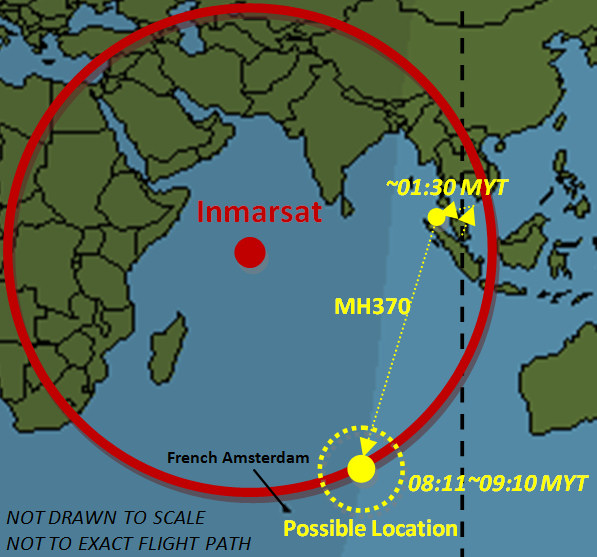
Because one earth circle = 360 degrees = 24 hours, then 1 hour = 15 degrees, and because the structure of degrees and hours is exactly parallel on the surface of our earth, 1 minute of time = 15 arcmin and 1 second of time = 15 arcsec, ��. If we know the coordinates of the last ��handshake�� pinged by Inmarsat to MH370 on these two corridors, delimited by the aircraft fuel range and ground radar data ranges from different nations, plus the advised results calculated by our theoretical framework and algorithm, we are pretty much very confident that the location of MH370 is within what we have proposed as conceptually illustrated in our proposed map. That is to place the location of MH 370 in the UTC +6 time zone area of north east of French Amsterdam��coordinates��30.50�� South, 77.30�� East��and west of Australian city of Perth��coordinate��31.95�� South, 115.86�� East��, subject to the deviation of how far south the plane could fly across the earth latitude lines, the flight height, the glide distance after the last ��handshake�� ping from the airplane at 8:11��MYT��. Good luck with our prayers.
David W. Pan, Ph.D., J.D., PD.B.
Toll Free Phone Number from China��950-4030-5511
US Phone number��918-250-9684
��������Ŀǰ�����й�MH370����IJ²⣬�������������ţ���ܷɻ�����λ����������֮һ�� ���Ǹ������������������������ϱ����ȵ���Ϣ������ѡ����������ݼ�������ġ�
����1����ӡ������ϲ�������ͼ�г�ɫԲȦ��
����2���ڱ����������Ӧ������
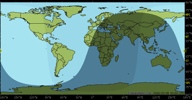
�������ڱ������ȵ����Ǻ���½�غ߶Ⱦ��»������磬פ�����״���������Ψһ�ĸ߶ȿ�������������ĵ�ͼ������ӡ������Χ�ƻ��ڳ�ɫ������Ϊ���ĵ㡣��ע�⣬��ͼ����δ������������Ҳ�������ɻ��ľ�ȷ����·�ߡ�����ʹ�õ��������Լ���һ�������㷨�����ۿ�ܽṹ���еļ��㡣���ǵļ����ǻ���������Ϊ����غͿ��ŵ���Դ������������Ϣ�����Dz������ڿ�չ��ѧ�о��Ļ���ԭ��
�������ǵ�ͼֽ�Dz�����������������MH370ʵ��������ȷ�еķ���·������Ϊ����û�й��ʺ���������֯���ڴ�MH370�ļ�������֡�����ʽ�л�õ����ݣ�����Ҳ���Էɻ���עȼ�͵���������������з��еij���ʱ�䡣���ǿ��Լؼ������ڷɻ����ʺ�������֮���40�Ƚǣ����������ա����֡��Ӵ�����Ϣ8��11[MYT]����һ����������������ѡ�������ݺϲ�ʹ�á���ȷȷ�� MH370λ����Ҫ��һ�������ݺʹ����Ķ�����㣬��ȡ���ڷɻ���8��11�֣�MYT�����ġ����֡�ʱ��ʵ�ʵĸ߶ȣ���������ʱ�����ڵ������Ͷ��������� �������ȡ����MH370�����ġ����֡�˲��ķ��и߶ȣ��������MH370�����Ե�������λ��= 0����Ͷ�����Ӱ���= 0���� ��Ҫ����777 ER- 200����˫������ֹͣ������ɻ��賤��20���ӵľ��롣���ǵ�����Ԥ����岽���о����¡�
����1�������г�ּ����������ţ��ɻ�����ʺ������ǵ����һ�������֡������ճ�ǰ�����ġ�
����2��2014��3��8�ռ�¡���ճ��ĵ���ʱ�䣨 MYT ����7ʱ21�֡�
����3����ܷɻ����һ��ͬ���ʺ���������֯��ӡ�����Ͽյ����ǡ����֡�����08:11 �� MYT �������������ƶϷɻ�����ʺ����������һ�νӴ���ping��������һ����8��11����9��10 �� MYT���ķ�Χ���������ٶ������ʺ���������֯�ġ����֡������һ��Сʱ���㣨ʵ��Ϊ��Сʱ����
����4����Ϊ��¡��MYTʱ���ճ�ΪUTC +8:00�����һ�������֡���MH370��λ��Ӧ����95���ĺܸ߸�����UTC +6:00ʱ���ڣ��������Ļ�����UTC+5��00��UTC +7:00ʱ����30�����ڡ� ���ܷɻ���������08ʱ11�֣� MYT �����һ�������֡��ĸ߶���Լ��
����5����ʹ����������ʱ��ͬ�ѹ������ϲ��ͱ����������ص����ǣ� ���ͨ�����Ƶõ�һ���������ε��������������С�������� MH370��777�ɻ�һ��������ڱ�����ṹ������������ڴ����ˮ�£�ȡ�������������ˮѹ��������
����6����Ϊ���DZ����Ѿ�֪������ɻ����ڱ������ȵ�ij��������������ڱ��������ѹ������������ǵ��״�ϵͳ�ڸô��ڵ�ʱ��û�м��MH370���κ�����UFO���������������Ψһ�ƶϣ� 777 ER 200 ������MH370 ��Ӧ������ӡ�����ϲ��İĴ����������ͷ�����ķ˹�ص�������֮���ij������������Ψһѡ��
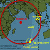
����7�����������Ѿ����������˿��ܵ����������ṩ�˴��µ�ͼ�ô��Ǹ�����-��Χ����������
��2014��3��19������09ʱ09��25�룬 Alan Pan and David Pan��
Where Could Be A Possible Location for MH370?
In light of current speculations in a wide range for whereabouts of MH370, we have reason to believe that the plane may be located in one of the following areas according to the corridors announced by Malaysian government and other data we have selected for calculation.
- The middle of the southern Indian Ocean as encircled in orange in the south corridor, or
- The corresponding area in the north corridor.
As the area of north corridor is most covered by land masses and heavily militarized��i.e., stationed with radars��, the only high possibility of the alternative is around or within the orange area in the southern Indian Ocean as circled in the map below. Please note that the map is drawn not to scale and not to the exact flight path. We have made our calculations using our proprietary algorithm and framework. Our calculation is based upon the published information we have selected from the sources we deem to be relevant and credible. The fundamental principles in conducting a scientific research have been followed.
Our drawing is not to scale, neither to represent the exact flight path actually made by MH370 because we do not have the Inmarsat data that was periodically received in form of the interval ��handshakes�� from MH370, nor we have the data on the air fuel amount that could be used to estimate the air flight duration. We simply can assume the published information of the final contact at a 40 degree angle between the plane and Inmarsat to be a constant and used it with other selected data. Any further pinpoint of MH370 location will require additional data and extensive calculations, depending upon the actual altitude the plane was flying at the last ��handshake�� at 8:11��MYT��and the projected shadowed area that is drawn on the surface of the earth, depending upon the flight height of MH370 at the moment of the last ��handshake����i.e., if MH370��s position from the earth surface = 0, then the projected shadowed area = 0��. Our projected propositions in steps are listed as follows.
- There is substantially strong reason to believe that the plane��s last ��handshake�� with Inmarsat happened before sunrise.
- The sunrise was around 07:21 local time��MYT��in Kuala Lumpur on March 8, 2014.
- The plane was last pinged by the Inmarsat��s satellite over the Indian Ocean at 08:11��MYT��, hereafter inferring the plane��s last contact with Immarsat has occurred in a range from 08:11 to 09:10��MYT��if the Inmarsat��s ��handshake�� interval is at a hourly rate.
- Because the time zone for the sunrise at MYT is UTC+8:00, MH370��s location of the last ��handshake�� should be marked within UTC+6:00 time zone with a high probability, if not within UTC+5:00 or UTC+7:00 time zone.
- Please use the above proposed time zones to overlay with the published southern and northern corridors. One will narrow the search areas significantly by drawing the scope of the areas of where the MH370 ��s 777 can be located.
- Since we would have known already if the plane were somewhere in the land area in the north corridor��most nations in the north corridor have publicly announced that their radar systems did not detect MH370 or any other UFO during that window time��, this leaves us with the only alternative to infer that the 777 ER 200��a.k.a. MH370��should be somewhere between the west of Australia and the northeast of French Amsterdam Island in the southern Indian Ocean.
- The above has significantly reduced the possible search area and offered the center from which the search should be conducted.��3/19/2014 9:09:25 AM, Alan Pan and David Pan��
Conceptual Rendition of MH 370 Possible Location
Based upon the selected published information using our proprietary algorithm and theoretical framework
��either area of UTC+6:00 time zone intercepting with the published southern and northern corridors as shown��
Adopted from:
http://www.timeanddate.com/astronomy/moon/light.html?n=122&day=8&month=3&year=2014&hour=8&min=10&sec=0
http://www.inmarsat.com/news/inmarsat-statement-malaysia-airlines-flight-mh370/
�ش�ͻ�ƣ����ްl�F����MH370����
���������R��MH370���C��Ŭ��20�հl���ش�ͻ�ơ����������^�l���Y������˹�⺣�l�F�ɂ��`���R��ʧ�͙C�����w�������������أ�Tony Abbott��20��������V�����f�����ޏ��l��Ӱ��l�F�����R��MH370���C�Ě��������ęCŞ�����s�����P������C��
���������ر�ʾ�ь��@�ӍϢ֪ͨ�R���������ࡣ������܊�����M��P8����ʽ��Poseidon���ɲ�C�ѽ��s�����P�������İ���Ş�b�����ڮ��ؕr�g20�հ����ɵ��_��
���������°�ȫ�֣�Australian Maritime Safety Authority, AMSA�����O�����John Young���ڮ��ؕr�g20������3�r30���e�еľo��ӛ�ߕ��ϱ�ʾ���������յ��l��ӍϢ���l�F���ܵ��ь�Ŀ�ˡ����ڌ��ҷ����l��Ӱ���ᣬ�l�F�@�����������R��MH370���C��������
��������ʾ������һ����Ʒ�s��78.7�գ�24���ߣ����l�F�����w�C�����ĺ����ڰ��������IJ�˹��Perth��������ӡ������2500���⡣���f���~���mҲ���ɳ��w�C���f���ь��������ь��΄��ˆT��ʾ����Ҋ���w�����š���������һ���������w��s��24�����L��